So, while I was researching my story about the old Lake Buena Vista STOLport, I spent a lot of time poring over old charts and trying to navigate several ridiculously labyrinthine governmental websites. All that staring at a monitor tends to make your eyes go crossed, and that’s what I thought had happened when I looked at a specific map from 2003 on the official Florida Department of Transportation website. It’s a highway map of Orange County that was created directly by the Florida DOT and the United States DOT’s Federal Highway Administration.
So, I scroll down to take a look at the Walt Disney World property…
So, that’s kinda cool. I was sad it didn’t have any detailed markings for the resort, but it’s interesting to see the boundaries of the cities of Bay Lake and Lake Buena Vista. I was especially amused that they list the populations of the two cities: Bay Lake with 23 residents, and Lake Buena Vista with 15 inhabitants. That should be me in my Club Lake Villa!
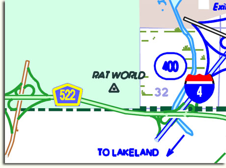
Anyway, the interesting thing that caught my eye is at the very southern end of property, near the line with Osceola County. Surely, I thought, my eyes deceived me. So, I zoom in. Nope, there is was, plain as day:
Rat World.
Rat World?!
That’s a pretty good burn, Florida Department of Transportation! I mean, it’s one thing to get slammed by some crank on the internet, but another entirely when the state and federal governments tag team to make fun of you.
Now, according to the key on the map, this marker is a triangulation station. These are apparently small survey markers littered across the world that allow surveyors, mapmakers and construction teams to do whatever it is that they do. Every marker’s location is accurately recorded in all three dimensions, which allows interested parties to measure distances and positions precisely.
And this one, located on Disney property near the Pop Century Resort, is called Rat World.
That’s pretty cold, surveyors. Although it is near Pop Century, so I can understand your sentiment.
I think that finding this designation on an official government chart is proof positive of the international Freemason conspiracy, the stranglehold on our society by the Trilateral Commission and the RAND Corporation, the Federal Reserve, Opus Dei and the Church of Scientology.
And they all. Hate. Mickey.
The truth is out there.


Oh that is just priceless. I have been pouring through the Reedy Creek Comp Plan (found the homes – Imagine a coup!). I am simply stunned by the wide latitude that Disney has with regards to land use that would make most counties jealous. Keep it coming.
It’s just too bad that they don’t use those powers to their full potential!
FYI… you can “visit” the residents of Bay Lake via Google Street View…
Here’s what I took away from this map:
1. Reedy Creek is nowhere near Reedy Lake!
2. Is the Florida DOT using the same artists who created the WDW guide maps in 1987?
3. World Showcase Lagoon is a real, natural body of water.
“I am simply stunned by the wide latitude that Disney has with regards to land use that would make most counties jealous.”
You should see what they get away with in the tax code!
Oh I have visited the housing sites! I have been tempted to show aerial photos on Samland but not sure how good of an idea that would be.
I have also been tempted, but have held back on that story several times for what are probably the same reasons. I just love it, though. It’s like the Dharma village. I need to do some on-ground recon sometime. It looks like they have their own little beach on Bay Lake!